
Many of my ex-pat clients are surprised when I mention that Alicante, Murcia, Almeria and Granada are regions with a high probability to have an earthquake.
It is really the whole southeast of the Spanish peninsula, the zone with an average seismic risk as in the recent case in Lorca (Murcia).
Earthquakes registered in the city of Lorca are not the first that has occurred in Spain. The southeast peninsula has a medium- seismic risk condition, with the potential to have an occurrence of up to a magnitude of 6 or 7 on the Richter scale. Spain has suffered several major earthquakes in its history with high fatalities. Currently, it is very difficult to predict the precise day and time of an earthquake, but scientists are working with several systems to know when an area is more likely to suffer an earthquake in a short period of time.

Which are the most recent earthquakes in Spain?
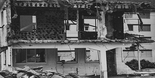
May 11, 2011, a date which will never be forgotten by the residents of Lorca. At least nine people died, more than two hundred were injured, and thousands of evacuated from their homes. It is the tragic toll of the two earthquakes in this Murcia town. The first happened at 17:05 pm with a magnitude of 4.5 on the Richter scale and the other at 18:47, with a magnitude of 5.1.
This tragic natural disaster has shown that Spain is not an area ofhigh seismic activity but is not free from possible earthquakes. From what is known so far, it is difficult in the Iberian Peninsula to have earthquakes more than 8 degrees on the Richter scale. The major scale would be 6 or 7.
The major earthquake that could occur in Spain would scale as much as 6 or 7.
Some areas are more at risk than others. There is a medium seismic risk in the southeast peninsula (Granada, Almeria, Alicante and Murcia), low in the rest of the peninsula, and high volcanic risk in La Palma and Tenerife.
The Lorca earthquake is not the first serious seismic activity that happened in Spain. Although the historical records don't show catastrophic seismic activity as in other parts of the world major disasters have occurred.
More than 250 years ago there was the Lisbon earthquake, which caused 40,000 deaths. In Spain, it was also noted that 2,000 people died. Another historical earthquake, such as Granada, in 1882, killed more than a thousand people. The website of the Ministry of Development lists the most destructive earthquakes in Spain, which have claimed the lives of thousands of people.
Can we predict earthquakes?
On the same day that the disaster of Lorca occurred, a canard which echoed by many media pointed to a supposed prophecy. It is asserted that Rome would suffer a major earthquake.
Any prediction to be considered to mobilize people and means would require a reliable and be sufficiently in advance and should provide specific data, the magnitude of the earthquake and a specific range of time in which it will be registered. No one is capable of doing that today.
No one can predict the precise day and time of an earthquake.
However, several scientific teams around the world are working to better understand these natural disasters and improve forecasting systems. Scientists have a seismic monitoring network and develop risk maps. The (IGN) National Geographic Institute under the Spanish Ministry of Public Works offers on its website data on earthquakes in the last ten days in Spain and the world, seismic reports on major events and seismicity maps of the peninsula Iberian and its surrounding areas.
To make reliable predictions, it has launched the Iberian-Mole. Its coordinator Mr Roberto Rodriguez says it has two different observation networks (GPS and seismic stations) and the participation of 107 scientists from ten institutions. Its aim is to predict within a short period of time where and when an earthquake of certain characteristics may happen.
In Chile, a similar system to the Iberian-Mole predicted last year that there would be a major earthquake.
With the data obtained, it may issue recommendations on the areas of Spain where earthquake-resistant construction standards must be more rigorous.
How to deal with an earthquake.
Given current knowledge, the only effective measure to prevent a catastrophe is prevention. Most victims of an earthquake are recorded by collapsing buildings or structures, falling objects, furniture, fire or broken gas pipes and electricity, as well as human acts themselves, due to recklessness and panic.
Experts recommend that buildings and infrastructure should take into account risk areas, and should be applied the necessary anti-seismic measures, in building design. To conduct drills and educational plans for the population, have rescue teams with specific training, etc.
I have to say that the building designed nowadays in Spain can withstand earthquakes of up to 7.5 degrees on the Richter scale without collapsing.
How we deal with earthquakes under the Spanish Building Code.
I am afraid that under the current circumstances, it may not be ethically correct to ask that question right now, but I am sure that more than one reader had wondered about the stability of their homes before an earthquake.
Although it is a highly technical matter, I believe that we can converse about the subject circumscribing to general information so that at the end of the following expositions some of us (including me, I had to carry out some research on the subject and dust up the old textbooks) would understand a little better how our buildings literally stand up, should an earthquake occur around East Spain.
The zones most likely to occur earthquakes in Spain are in Granada, Murcia and Alicante.
In recent years in Spain, earthquakes with magnitudes greater than 4 degrees (Richter scale) have taken place causing considerable damage to buildings. For example, the earthquakes in Andalusia on Dec. 23rd, 1993 and January 4th, 1994 with intensity in both cases of 5.0 degrees and with epicentres in the province of Almería, near the towns of San Roque and Berja, and 20 km from the coast off Almerimar Balerma and Bath respectively (Yépez, 1994). In Galicia on May 22nd, 1997 with an intensity 5.1 and centred near the towns of Sarria and Becerreá and the latest occurred in Murcia on February 2nd, 1999, of intensity 5.0 and centred about 5 km north of Mula (Mena, in 1999).
There are historical records of great seismic activity in southern Europe in countries such as Turkey, Greece, Yugoslavia, Italy, Portugal, and of course Spain.
Devastating earthquakes, such as the one on the 1st of November 1755 on the southwest of the Iberian Peninsula, produced high waves and their destructive power caused between 50,000 and 70,000 deaths. In Lisbon and surrounding areas on December the 25th of 1884, an earthquake killed 800 people. In Alicante in the year 1500, another earthquake destroyed some 4,400 homes and damaged 13,000. In Messina Italy, 28th of December 1908 an earthquake killed 120,000 people and caused considerable damage to the infrastructure of the city.
The two seismic activities which have produced the highest numbers of deaths happened in China, one in 1556 in the province of Shaanxi, where 830.000 people died and more recently, in 1976 an earthquake of intensity 7,6 in the region of Tangshan, generated 650.000 deaths.
I haven’t found records on the economic losses which obviously are concatenated with disasters of that enormity, and most important o all, there are no way of quantifying grief and suffering generated by the loss of loved ones. It is not a trivial issue what we have here.
But why do earthquakes occur?
Earthquakes occur when stresses accumulated due to the deformation of the earth’s layers are released abruptly. Broken masses of rocks sometimes large as whole mountains are subject to enormous forces and rearrange themselves releasing enormous energies that shake the earth’s surface with tremendous force. The (hypocentres) are located at different depths, the deepest being up to 700 kilometres. They are particularly common near the edges of tectonic plates. Believe it or not, there are about one million earthquakes recorded every year, although most of them are of such low intensity that goes unnoticed by us.
They act instantaneously over a wide area and can cause seismic waves, (tsunamis) similar to the recent one in Japan that was transmitted live worldwide and may also cause landslides, the appearance and disappearance of springs, construction damage and deaths, mostly due to the collapsing of buildings.
They are very difficult to predict and, at present, there are no effective systems to warn people in advance of an imminent earthquake.
Intensity and magnitude of earthquakes
To describe the strength of an earthquake and resulting damage, their different scales that measure their intensity and magnitude.
We can measure its intensity, which is a subjective measure of the effects of earthquakes on the earth’s surface, people and man-made structures but without using any technical instruments. It is based on observing the consequences that take place during an earthquake. It is useful to explain an earthquake in areas where there are no seismographs near and enable us to compare ancient earthquakes.
The magnitude is an objective measure of the energy of an earthquake which is reflected by seismographs. The best-known and used scale is the Richter scale (1935) which measures the logarithm of the maximum amplitude of a seismogram recorded by a standard instrument, at a distance of 100 kilometres from the epicentre. This method has been corrected later, but the basic idea remains the same. As the scale is logarithmic every step up involves multiplying by ten the intensity of the lower number. i.e. Roughly speaking an earthquake grade 7 is equal to one of intensity 6 multiplied by ten. There are 12 degrees in the scale from 1 to 12 is 1 so small that is only felt by technical apparatus.
An earthquake measuring 12 on the Richter scale would break the earth in two.

This concept allows the classification of earthquakes:
Complete destruction, M = 12
Large earthquakes, M > = 7
Moderate earthquakes, 5 = < M < 7
Small earthquakes, 3 = < M < 5
Microearthquakes, M < 3
The EMS scale is officially used in most European countries and is utilized in the calculation of buildings and all types of structures by architects and engineers in Spain known as “Norma de Construcción Sismorresistente: Parte General y Edificación (Ncsr-02)” Earthquake-Resistant Norm.
Now that we have established the basic principles for measuring earthquakes, we will examine what precautions we architect take when designing buildings in Spain.
The “Norma de Construcción Sismorresistente: Parte General y Edificación (Ncsr-02)” Spanish Earthquake-Resistant Norm classifies buildings in accordance with their intended use and with the damage, their destruction can cause, they are classified as:
Buildings are moderately important.
Buildings with a negligible probability that their destruction during an earthquake may cause any casualties, disrupt a primary service, or cause significant economic damage. For example warehouses or agricultural buildings with access restricted to a small number of people.
Important buildings.
Buildings that if destroyed by an earthquake can cause casualties, disrupt services to the community, or cause significant financial loss, but their destruction does not interrupt an essential service to the community or may produce catastrophic effects. Residential buildings are catalogued here.
Particularly important buildings.
Buildings that if destroyed by an earthquake could disrupt essential service or lead to catastrophic effects and at least the following buildings are included:
Hospitals, health centres. Radio television, telephone and telegraph facilities. Buildings used for support personnel and equipment such as fire stations, and police. Buildings used for basic services supplies such as water deposits, gas, fuel, pumping stations, distribution networks, electrical power etc. Large civil engineering structures such as nuclear power plants or power stations, large dams and those that, may result in potential risk from their failure. Buildings are classified by the local authorities as historic or artistic monuments.
The application of this Norm on the calculation of their structure is mandatory in all the “Important buildings” i.e. residential buildings, but depending on the region of Spain they are situated. Here in south-east Spain, the majority of municipalities fall under zones with a seismic acceleration higher than 0,08g (g = to gravity) that figure the limit for buildings to be calculated against earthquakes and include all “Particularly important buildings” and structures.
We also saw that this EMS scale is divided into intensities, let us give a description of the effect each grade may cause.
Grade I: the shock is not perceived by human senses, being detected and recorded only by seismographs.
Grade II: the shock is perceptible only by some people while at rest, especially on upper floors of tall buildings.
Grade III: the shock is perceived by some people within buildings. The vibration perceived is similar to that caused by the passage of a light truck.
Grade IV: the earthquake is perceived by people inside buildings and some outside, but it is not scary. The vibration is comparable to that produced by the passage of a heavy truck. Windows, doors and dishes rattle. The furniture starts moving.
Grade V: The earthquake is felt by most people inside and outside of buildings. Some people instinctively start to run away. Animals get nervous.
Grade VI: The earthquake is felt by all people, inside and outside. Many people take to the streets in panic, some lose their balance. Animals run away. Crockery and glassware break, books fall from shelves, pictures move or fall from walls and unstable objects are overturned. Church bells toll by themselves. There are moderate damages in some constructions.
Grade VII: Most people are terrified and run into the street. Many have difficulty keeping up. Vibrations are felt by people driving cars. Load-bearing wall construction may suffer serious damage and some reinforced concrete buildings may be affected. Changes happen to the flow of springs and rivers. In some cases, the wellspring appears in new places and others disappear.
Grade VIII: Fear and panic are widespread, even in people driving cars. In some cases, branches of trees are torn off. Furniture, including heavy furniture, move or is overturned. Hanging lamps are smashed against the ceilings due to the movement of the buildings. Many load-bearing buildings are destroyed and some collapse. Reinforced concrete buildings may suffer serious damage and some are destroyed. Cracks appear on the ground several centimetres wide.
Grade IX: There is total panic. Most load-bearing walls of buildings will collapse. Many reinforced concrete buildings not designed for an earthquake will suffer heavy damage and some will collapse. Underground pipes will be partially broken. In some cases, railroad rails will curve and be out of service. Cracks up to 10 centimetres wide will appear on the ground. Rocks will fall from mountains in some cases even avalanches of rocks. Many landslides will happen. Big waves could be seen in lakes and reservoirs.
The biggest earthquake recorded on earth.
Incidentally, the biggest earthquake recorded on earth was in Chile in the city of Valdivia, the earthquake had a magnitude of 9.5. There were 2,000,000 people made homeless. Valdivia sank 4 metres below sea level and caused the eruption of the volcano Puyehue. The quake was felt across the southern hemispheres, and a tsunami swept across the Pacific Ocean, reaching Hawaii and Japan.
Up to here we have had points of reference with earthquakes that have taken place before, from scale X on, there is a degree of speculative conjecture as to what may happen, even though scientists consider that the following may take place:
Grade X: Most load-bearing buildings will collapse. Serious damage will be inflicted on reinforced concrete o steel buildings. Great damages may occur to dams, bridges, and railways. Most underground pipes will break. Street paving and road asphalt will form large waves. Cracks on the ground could form from a few centimetres to a meter wide. Landslides will occur on most mountains. New lakes will form.
Grade XI: Most constructions will suffer severe damaged or will be collapsed. Damage will be caused to most major dams, bridges and railway lines. Most roads will be out of service. Most underground pipes will be destroyed. Ground will be significantly deformed by both land movements and rock falls. The skyline will change.
And for the mother of all earthquakes .…
Grade XII: All structures and buildings are virtually destroyed or are severely damaged including those built underground. The topography would undergo great changes. Large cracks in the ground bigger than a metre will appear with significant horizontal and vertical displacements. Falling rocks and subsidence occur in most valleys some of them disappearing and transforming them into lakes new ones appearing. The skyline will change dramatically and probably the whole world.
Write a comment