
I have just returned from a short holiday in USA and was greatly impressed by the widely used of drones in the private sector. It might be that I was on the lookout for them but they seemed to be available almost anywhere. I think that it use in architecture could be invaluable specially in building and land surveys, but let us examine what they are and its uses.
Drones, or UAV (unmanned aerial vehicle) are flying aircraft without a crew. Currently there are a variety of shapes, sizes and features according to the use for which they are intended.
These devices have great potential in different areas because they can move through areas of high risk or difficult access and overcome any obstacle, offering aerial images and collecting different data without jeopardizing the life of any crew.
Despite its military origin, the civil market has managed to see its potential and today many companies use drones to perform various tasks:
Cartography and topography.
The most common is use of drones to make topographical measurements in inaccessible areas. The functions of these devices are mainly two; they can photograph a given area in a great detail and although this method is less precise than others, allows having more information for any given project. In addition some drones have a laser that can make a representation of the ground through a cloud of points (LIDAR technology). After all data is collected the cloud of points is then passed to a plan making possible to obtain a 3D picture of the ground.
The advantages of the use of UAVs with respect to other measurement technologies mainly lay in that the drones allow taking data in real time and since they are of small size it can be transported easily. The usual method to carry out these tasks was previously by contracting of an aircraft that conduct measurements, a fact that it could take months due to the availability of air facilities and obviously the costs are unmatched.
Drones and the environment.
These devices are an economical option to ensure the protection of the environment, not only from surveillance and control, but also a form to combat actively pollution. We could also record the evolution of vegetation growth of areas repopulated after a fire, study plants in danger of extinction or carry out monitoring of the fauna. The low noise level of the electrical drones allows observing wildlife in their natural habitat without disturbing their life cycle.
In Japan, the Government has also begun to use these devices to combat pollution in the air, since these airplanes can be loaded up to 700 kilos of chemicals used to clean air pollution.
Natural hazards.
The drones are an excellent tool to minimize and control potential natural hazards, such as forest fires, volcanic eruptions, or hurricanes.
One of these examples is Nitrofirex, a Spanish business project that proposes "deposits unmanned self-propelled gliders (DPA) ". These drones would be suitable for forest fire control: it can accommodate up to 2,500 liters of water (half a conventional tanker aircraft), do not need people for these risky missions, and can even fly at night, when conventional aircrafts must land although the fire continues.
Landscape.
Any visual impact of large developments can easily be estimated at landscape level.
Maintenance.
Control and monitoring of facilities. An example in which is carried out in Spain is by the electric company Endesa already using drones equipped with high-resolution cameras, to record and review the status of the power supply and conditions of the existing infrastructure such as pylons and steel towers.
Agriculture.
Agriculture could be one of the main drivers of UAVs for civilian uses, allowing to control and monitor the status of crops through multispectral images. Also capable of controlling the efficiency of irrigation systems or for counting and monitoring agricultural production (counting number of plants). One of these examples is the French company Airinov which has created a model for mapping of agricultural land.
These devices represent a valuable tool to ensure the protection of the environment, to improve the profitability of crops and territorial management.
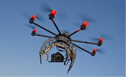
Architecture and surveys.
We could make great use of these drones for example to survey buildings, many times we find that we don´t have access to the top of roofs or eaves or to thoroughly inspect façades of very tall buildings etc.
A very useful tool indeed.
Write a comment